
Raymarine Lighthouse Chart: R70794-NEU - Northern Europe - SD Card
Take command with LightHouse Charts Western Europe. Discover visually stunning, customizable marine charts with color-shaded depth contours, data-rich points of interest, and superior clarity that only Raymarine can provide. LightHouse Charts allow you to uncover every detail and explore without limits. Compatible with Raymarine Axiom, Axiom+, Axiom Pro, Axiom XL, and Raymarine Element.
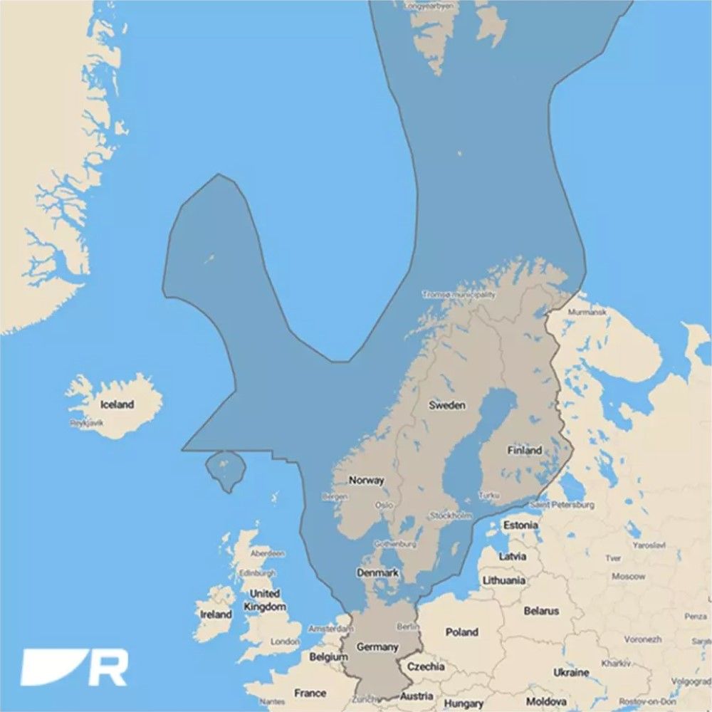
Nautical chart coverage area includes Norway, Sweden, Finland, Denmark, and Germany.

- Enhanced Chart Symbol Control
- Flexible Color Modes
- Professional or Leisure Chart Style
- Includes 1 Year of LightHouse Charts Premium Subscription
- Nautical chart coverage area includes Norway, Sweden, Finland, Denmark, and Germany.
Take command with LightHouse Charts Western Europe. Discover visually stunning, customizable marine charts with color-shaded depth contours, data-rich points of interest, and superior clarity that only Raymarine can provide. LightHouse Charts allow you to uncover every detail and explore without limits. Compatible with Raymarine Axiom, Axiom+, Axiom Pro, Axiom XL, and Raymarine Element.
Smart Charts Make navigating Easier
Enhanced Chart Symbol Control - Change the size of channel markers, points of interest, and other icons for complete control over chart details.
Flexible Color Modes - Day, SuperDay, Dusk and Night color palettes help your vision keep up with changing light conditions for clear, strain-free chart viewing.
Choose Your Chart Style - Toggle between the information-rich LightHouse Leisure Chart style and the professional S-52 Government Chart style for your preferred view of key cartographic data.
Discover More With Lighthouse Chart Premium
Stay Up To Date and Explore More - With Lighthouse Charts Premium, our latest charts are always available for download.
Expansive POI Library - Quickly find local marinas, fuel stops, service stations, and more with and ever-expanding points of interest library sourced from leading providers.
Navigate with A Real-World View - Access Mapbox-powered high-resolution satellite imagery* for a complete view of streets, shorelines and shallows for informed decision making.
*Only available with a LightHouse Charts premium subscription
Lighthouse Premium Partners
Mapbox - Mapbox is a leading provider of location-based data for online and mobile applications. Mapbox high quality maps are used by over 600 million users every month. Mapbox delivers global satellite and aerial imagery along with detailed land-based street and points of interest data to LightHouse Premium subscribers
Marinas.com - The world’s number-one searchable marina directory, Marinas.com, connects boaters with over 75,000 local marinas, anchorages, and marine locations. LightHouse Premium subscribers can explore the extensive Marinas.com directory within LightHouse charts by simply touching any of the user-friendly Marinas.com icons overlaid on the navigation chart
Waterway Guide - Since 1947, Waterway Guide has been an indispensable source for North American boaters exploring the Eastern United States, Bahamas, Turks & Caicos, Great Lakes, and the Gulf of Mexico from Key West to South Padre Island, Texas. LightHouse Premium subscribers will enjoy mile-by-mile navigation information, aerial photography with marked routes, marina listings and locator charts, and anchorage information.
Reeds Almanac - Reeds Nautical Almanac is the indispensable trusted compendium of navigational data. Reeds’ marina and almanac area guides are part of the LightHouse Premium subscription. Reeds data covers the Atlantic coastal waters around the whole of the UK, Ireland, Channel Islands and the entire European coastline from the tip of Denmark right down to Gibraltar, Northern Morocco, and the Azores.
Navily - Navily is the leading cruising guide in Europe with 165,000+ contributions on 30,000+ anchorages and marinas across the globe. Gain access to this crowd-sourced, community of charting data on your Raymarine display when upgrading to LightHouse Charts Premium.
Pagine Azzurre - With coverage of 878 ports on the Italian Coast, as well as the Côte d'Azur, Corsica, Slovenia and the main ports of Croatia, Pagine Azzurre is an essential source for charting information for this treasured section of the world. Enjoy your next cruise around Italy even more as a LightHouse Premium subscriber.