
Garmin GPSMAP 1623xsv - Chartplotter & Sonar
With its sleek design, powerful processing and upgraded IPS display, this advanced 16″ chartplotter integrates seamlessly into a Garmin marine system.
- Easily integrate with more engines.
- Easily build a marine system by using our advanced network connectivity.
- Support for Garmin Navionics+ and premium Garmin Navionics Vision+ cartography.
- See below your boat with built-in sonar capabilities
- Manage your marine experience from nearly anywhere
Technical Specifications
X| General | |
|---|---|
| Dimensions | 38.4 x 26.2 x 7.6cm (15.1″ x 10.3″ x 3.0″) |
| Weight | 4.4Kg |
| Waterproof Rating | IPX7 |
| Input | Touchscreen |
| Display Type | FHD, IPS |
| Display Size | 34.5 cm x 19.5 cm; 39.7 cm diagonal (13.6″ x 7.7″; 15.6″ diagonal) |
| Display Resolution | 1920 x 1080 pixels |
| Mounting Options | Bail, flush or flat |
| Maps & Memory | |
|---|---|
| Accepts Data Cards | 2 microSD Cards (back of unit) |
| Waypoints | 5,000 |
| Track Points | 50,000 |
| Tracks | 50 Saved Tracks |
| Navigation Routes | 100 |
| Sensors | |
|---|---|
| Built-in Receiver | ✓ |
| Receiver | 10Hz |
| NMEA 2000 Compatible | ✓ |
| NMEA 0183 Compatible | ✓ |
| GPS | ✓ |
| GLONASS | ✓ |
| GALILEO | ✓ |
| Supports WAAS | ✓ |
| Built-in Maps | |
|---|---|
| Tidetables | ✓ |
| Optional Map Support | |
|---|---|
| Garmin Navionics+ | ✓ |
| Garmin Navionics Vision+ | ✓ |
| TOPO 100k | ✓ |
| Standard Mapping | ✓ |
| Garmin Quickdraw Contours | ✓ |
| Raster Chart Support | ✓ |
| Chartplotter Features | |
|---|---|
| Garmin Smartmode Compatible (Customisable Monitor Presets) |
✓ |
| AIS | ✓ |
| DSC | ✓ |
| Fusion-Link | ✓ |
| GSD Black Box Sonar Support | ✓ |
| GCV Black Box Sonar Support | ✓ |
| ActiveCaptain App Compatible | ✓ |
| GRID (Garmin Remote Input Device) Compatible | ✓ |
| Wireless Remote Compatible | ✓ |
| Sailing Features | ✓ |
| Spoken Audo Alerts | ✓ |
| OneHelm Support | ✓ |
| Sonar Features & Specifications | |
|---|---|
| Displays Sonar | ✓ |
| Traditional Sonar | Built-in (Single channel CHIRP 50/70/83/200 kHz, L, M, H CHIRP) |
| ClearVu | Built-in 260/455/800/1000/1200 kHz) |
| SideVu | Built-in 260/455/800/1000/1200 kHz |
| Panoptix Sonar | ✓ |
| Livescope | ✓ |
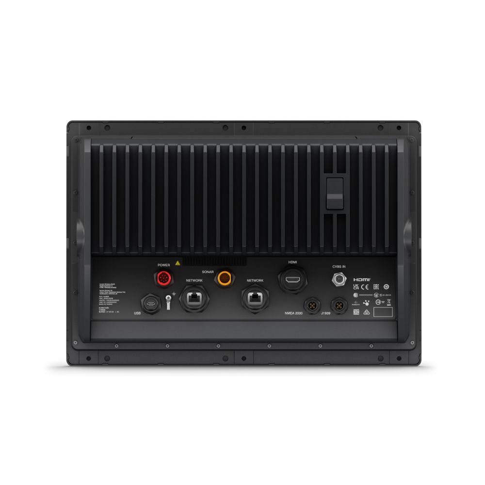
| Connections | |
|---|---|
| NMEA 2000 Ports | 1 |
| NMEA 0183 Input Ports | 1 |
| NMEA 0183 tx Ports | 1 |
| Video Input Ports | 1 BNC |
| Video Output Ports | 1 HDMI |
| J1939 Ports | 1 |
| Garmin Marine Network Ports | 2 |
| 12-Pin Transducer Ports | 1 |
| USB Ports | ✓ |
| Bluetooth Calling | ✓ |
| ANT+ Connectivity | ✓ |
| Garmin Wi-Fi Network | ✓ |
| Electrical Features | |
|---|---|
| Power Input | 10 - 32 VDC |
| Typical Current Draw at 12V | 2.9A |
| Max Current at 12V | 3.73A |
| Max Power Use at 10V | 46W |
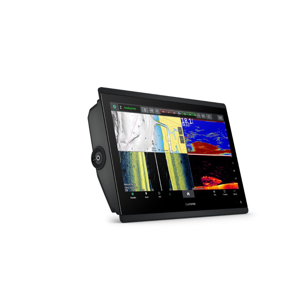
Get A Sharper View From A Connected Helm
With its sleek design, powerful processing and upgraded IPS display, this advanced 16″ chartplotter integrates seamlessly into a Garmin marine system.
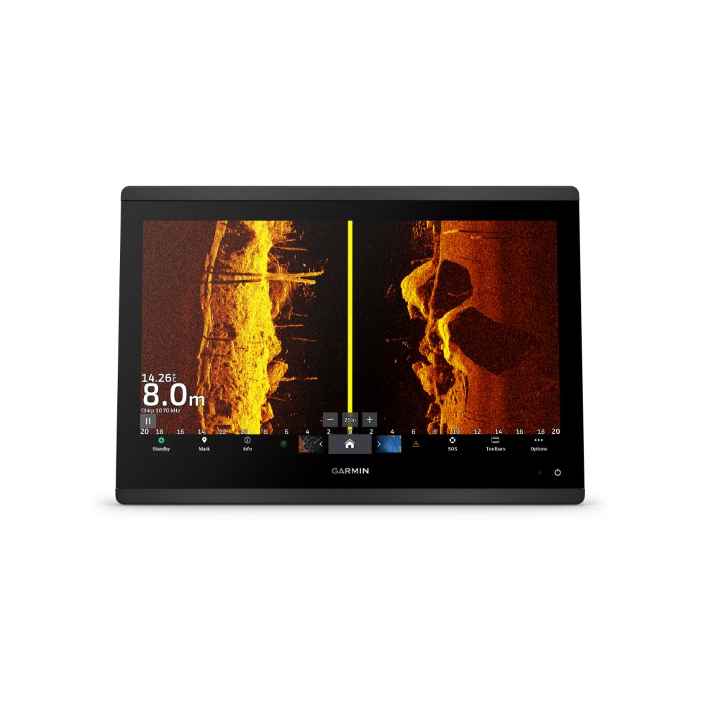
See The World Below
Ultra High-Definition Scanning Sonar - Get built-in Ultra High-Definition SideVü and ClearVü scanning sonars with vivid, high-contrast colour palettes to help distinguish fish from structure. The GPSMAP X3 chartplotter series also supports 1 kW traditional sonar capabilities.
Panoptix Sonar Support - Pair with Panoptix or LiveScope easy-to-interpret live sonar (transducer required, sold separately) to see all around your boat in real time.
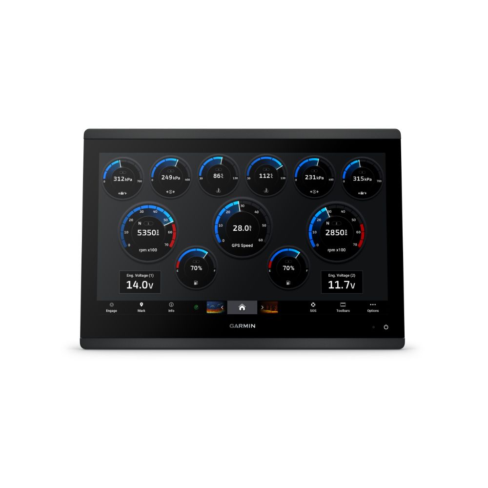
Made For The Helm.
Faster, Sharper, Smarter - With its added processing power and slimline design featuring edge-to-edge glass, it’s easy to fit this plotter in a wider range of dash configurations.
Bright and Clear Optics - High-resolution IPS displays offers improved sunlight readability and visibility from any angle.
Charts and Maps - Bring a fresh new look and feel to the chartplotter with optional Garmin Navionics+ or premium Garmin Navionics Vision+ cartography featuring integrated coastal/inland content, access to daily updates, Auto Guidance+ technology and more.
Power-Pole Shallow Water Anchor - By networking selected Garmin chartplotters with a Force trolling motor and a compatible Power-Pole shallow water anchoring system, you can access advanced boat control features from the plotter, including smart anchor auto-deployment, smart anchor jog, auto stow, anchor drag detection and auto guidance end-of-route anchoring. Spend more time fishing, less time positioning.
Trolling Motor Integration - Get support and integration for a Force trolling motor (sold separately) to gain complete control while you fish.
Charge Integration From Power-Pole - CHARGE Marine Power Manager from Power-Pole integrates with compatible Garmin chartplotters to help keep the battery power going longer and stronger on the water. Charge batteries on the run, monitor power use, select where power is allocated, control emergency starts and even transfer power between battery banks all from the chartplotter display.
Sail and Navigate with Ease
Garmin Sailassist Sailing Features - View laylines, race start line guidance, enhanced wind rose, heading and course-over-ground lines, true wind data fields and tide/current/time slider, wind angle, set and drift, wind speed and more.
Sailing Polars - Use the polar table to see key data, including how fast the boat should go at a certain wind angle and speed - know whether there is a need to adjust sail trim.
Garmin Marine Network - If you have multiple compatible Garmin devices on the boat, you can share information - such as maps, user data, radar and IP camera video.
NMEA 2000 and NMEA 0183 Networks - Connect to compatible autopilots, digital switching, weather, the Fusion audio system, media, VHF, AIS and more from one screen.
Activecaptain APP - Built-in Wi-Fi connectivity pairs with the free all-in-one mobile app for access to the OneChart feature, smart notifications, software updates, Helm app, Garmin Quickdraw Community data and more.
Integrated ANT Technology - Connect with devices, such as quatix marine watches, gWind Wireless 2 transducers GNX Wind marine instruments and wireless remote controls.
Engine Connectivity - Connect the chartplotter to different engines, including select Yamaha engines.
Onehelm Feature - This feature brings together all the operations and capabilities of select third-party devices, such as EmpirBus digital switching, on one screen.
Send Inreach Device Messages - Pair an inReach satellite communicator to the chartplotter, and type custom messages using the MFD’s on-screen keyboard. Access the contact list or enter an email, inReach address or phone number. It can also group messages by conversation for a texting-like experience.
In The Box
- GPSMAP 1623xsv Chartplotter
- MicroSD card preinstalled
- Power cable
- Flush mount kit with gasket
- Protective cover
- Trim piece snap covers
- Backbone/drop cable (2 metres) and T-connector for the NMEA 2000 network
- Documentation